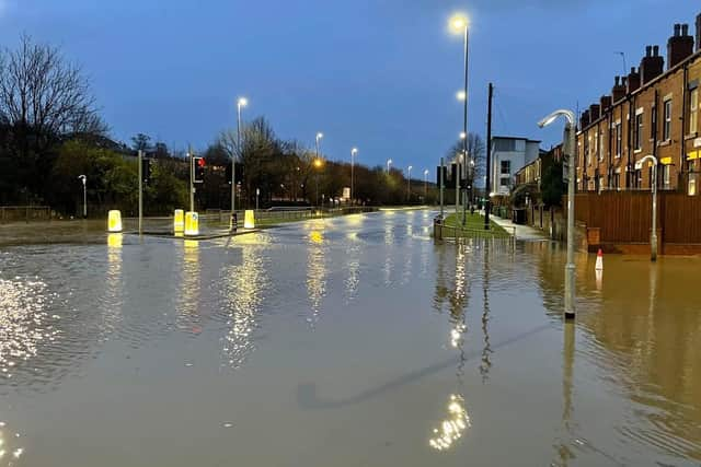
Storm Franklin: All the flood warnings in place across Leeds with 30 'flooding is expected' alerts
and live on Freeview channel 276
Below is the full list of flood alerts and warnings in Leeds to be aware of today (Monday, February 21).
Flooding on the rail line between Leeds and Shipley has already led to significant delays and cancellations.


Advertisement
Hide AdAdvertisement
Hide AdMeanwhile houses in Wortley were left flooded last night after the River Aire burst its banks.
Please note that this list only includes the 30 locations where flooding is expected. A full list of locations where flooding is possible can be found on the Check For Flooding service on the GOV.UK website.
Batley Beck at Bradford Road through central Batley
No further significant rainfall is forecast in the next 24hours and river levels in Batley Beck are expected to gradually fall throughout today.
Batley Beck at Carlinghow and Crossbank
No further significant rainfall is forecast in the next 24hours and river levels at Carlinghow are expected to gradually fall throughout today.
Collingham Beck at Collingham
Advertisement
Hide AdAdvertisement
Hide AdThe current level of the River Wharfe at Collingham is 4.5m, and is expected to continue to rise until around midnight.
River Aire at Allerton Ings, Barnsdale Road and Properties
Allerton Ings are filling as designed. Spilling into the Ings is expected to continue until early Monday afternoon.
River Aire at Cardigan Fields Leisure Park and Kirkstall Works
Areas most at risk are Cardigan Fields and Kirkstall works businesses. Further rainfall is forecast over the next 12 hours.
River Aire at Cardigan Trading Estate
Advertisement
Hide AdAdvertisement
Hide AdAreas most at risk are properties at Cardigan trading Estate. Further rainfall is forecast over the next 12 hours.
River Aire at Cottingley
Areas most at risk are areas around the Bradford and Bingley Sports Club. River levels have peaked and will remain high throughout this morning.
River Aire at Esholt and Apperley Bridge
No further significant rainfall is forecast in the next 24 hours. Expect to be able to remove this warning later today.
River Aire at Shipley
River levels have peaked but remain high as a result of persistent (heavy) rainfall. Consequently, the risk of flooding remains.
River Calder at Bradley
Advertisement
Hide AdAdvertisement
Hide AdRiver levels have risen as a result of heavy rainfall this afternoon. Consequently, flooding of property and roads is possible with Lower Quarry Road Trading Estate likely to flood.
River Calder at Central Mirfield
River levels are forecast to rise as a result of heavy rainfall. Consequently, flooding of property and roads is possible.
River Calder at Dewsbury - Lodge Farm and Sands Mill
Areas most at risk are properties in the Lodge Farm and Sand Mills area. River levels expected to remain high throughout today.
River Calder at Methley and Mickletown
Please avoid using low lying footpaths near local watercourses and plan driving routes to avoid low lying roads near rivers, which may be flooded.
River Calder at Ravensthorpe
Advertisement
Hide AdAdvertisement
Hide AdRiver levels on the Calder have risen as a result of heavy rainfall. Consequently, flooding of property and roads is possible this evening.
River Calder at Stanley
River levels on the Calder have risen as a result of heavy rainfall. Consequently, flooding of property and roads is possible this evening.
River Calder at Whitwood Mere
Consider putting your flood plan into action.
River Calder at Whitwood Mere and Methley riverside properties
Please plan driving routes to avoid low lying roads near rivers, which may be flooded, and put your flood plan into action.
River Crimple at Pannal and Burn Bridge
Advertisement
Hide AdAdvertisement
Hide AdDo not attempt to walk or drive through flood water. Start acting on your flood plan if you have one.
River Wharfe at Billams Hill and riverside properties between Otley and Pool
Levels on the River Wharfe have fallen overnight and are forecast to continue falling, however they remain higher than usual.
River Wharfe at Boston Spa
Levels on the River Wharfe are rising due to intense rainfall over the last 24 hours during Storm Eunice.
River Wharfe at Burley in Wharfedale
Advertisement
Hide AdAdvertisement
Hide AdA flood warning remains in force for River Wharfe at Burley in Wharfedale, due to recent heavy rainfall. River levels have fallen since yesterday so the risk of flooding has reduced.
River Wharfe at Castley Lane
A flood warning remains in force for River Nidd at Castley Lane due to recent heavy rainfall. River levels have fallen since yesterday but remain above normal.
River Wharfe at Denton Road Ilkley
River levels have peaked and will remain steady, with no further rise forecast.
River Wharfe at Harewood Bridge
Further showers are forecast through Monday and into Tuesday. Levels are being monitored closely.
River Wharfe at Ilkley
Advertisement
Hide AdAdvertisement
Hide AdA flood warning remains in force for River Wharfe at Ilkley due to recent heavy rainfall. River levels have fallen since yesterday so the risk of flooding has reduced.
River Wharfe at Otley
Further showers are forecast through Monday and into Tuesday. Levels are being monitored closely.
River Wharfe at Pool in Wharfedale
Avoid using low lying footpaths and any bridges near local watercourses and do not attempt to walk or drive through flood water.
River Wharfe at Tadcaster
Plan driving routes to avoid low lying roads near rivers, which may be flooded.
River Wharfe at The Avenue Collingham and Linton Ings
Advertisement
Hide AdAdvertisement
Hide AdExpecting some overtopping of defences at these levels and are deploying pumps to the area.
River Wharfe at Wetherby
Areas of particular concern are at Bridge Foot by the Wilderness car park, and Scott Lane, Wetherby. Further rainfall is expected overnight.
Support the YEP and become a subscriber today. Enjoy unlimited access to local news and the latest on Leeds United. With a digital subscription, you see fewer ads, enjoy faster load times, and get access to exclusive newsletters and content. Click here to subscribe.