This is what a Leeds transport map would look like if we had a tube


Being able to travel around the city on a fast, convenient, integrated transport system is something us Loiners can only dream of.
It’s a thought that’s occurred to software developer Rich Daley - the creator of this brilliant fantasy Leeds tube line map.
Advertisement
Hide AdAdvertisement
Hide AdRich, 36, loves Leeds, but says public transport lets us down.
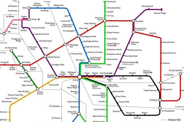
They first created their “alternate reality” in 2013 and updated it in 2014.
A few things have changed - New Dock is now Leeds Dock, and Leeds Metropolitan University is now Leeds Beckett University.
But the fundamentals remain the same.
Unfortunately, six years on, that remains true for the poor state of Leeds’ public transport - according to Rich.
Advertisement
Hide AdAdvertisement
Hide AdThey said: “I think public transport in Leeds is a major embarrassment for this otherwise amazing city.
“Years of political infighting and virtual monopolies on areas of Leeds by the bus companies have left us basically exactly where we were when I first moved here in 2010.
“The new Clean Air Zone would have been great for public transport if it had included private cars, but because they're excluded the roads are as congested as they ever were.”
Advertisement
Hide AdAdvertisement
Hide AdThey said those in charge of public transport seem afraid to say ‘making walking/cycling/public transport better does make travelling by car harder, and that's a good thing’ - unlike some other councils, like Waltham Forest in London.
“They're more worried about offending car users than they are about making the city liveable for those of us who can't or choose not to drive,” added Rich, who owns software development business Fish Percolator, out of Duke Studios in the city centre.
Public transport policy in Leeds is controlled by Leeds City Council and the West Yorkshire Combined authority, which the council is part of.
Advertisement
Hide AdAdvertisement
Hide AdLeeds City Council point out that there Connecting Leeds plan, started in 2016, has already resulted in cleaner buses, park and ride hubs, major highway improvements and cycling infrastructure.
Plans for the future include developing three new rail stations for key development and economic hubs serving Leeds Bradford Airport, Thorpe Park and White Rose and creating a new Leeds high frequency bus network – where over 90 per cent of bus services will run every 10 minutes between 7am and 8pm.
The West Yorkshire Combined Authority and the Leeds City Region Enterprise Partnership have set up a £1billion West Yorkshire-plus Transport Fund, covering West Yorkshire and York.
It will fund motorway, road and rail improvements across the district.