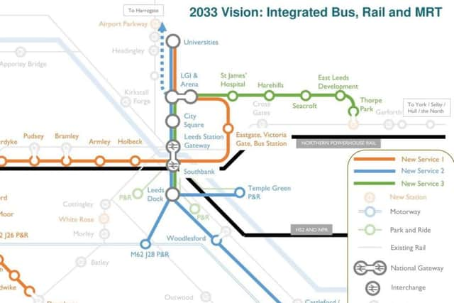
Tube-style map shows how a mass transit system for Leeds could look


Plans for three new transport links which would incorporate some existing public transport, have been proposed by West Yorkshire Combined Authority.
It has not yet been decided what type of vehicle would be used but it is hoped that it could incorporate new technologies like battery technologies, hydrogen propulsion and “autonomous innovations.”
Advertisement
Hide AdAdvertisement
Hide AdThe aim is for the network to be up and running by the early 2030s to tie in with High Speed Rail arriving in West Yorkshire.
Where would it stop?
The stops have been proposed by West Yorkshire Combined Authority to connect areas of the county that currently have poor transport links.
Line one would link Dewsbury - Heckmondwike - Cleckheaton - M62 Junction 26 park and ride - Low Moor - South Bradford - Bradford Interchange - Bradford Foster Square - Laisterdyke - Pudsey - Bramley - Armley - Holbeck - Southbank - Eastgate, Victoria Gate bus station - LGI and the arena.
Line two would link the Universities - LGI and Arena - City Square - Leeds station - Southbank - Leed Dock - Temple Green park and ride/Woodlesford and Castleford/M62 junction 28 park and ride.
Advertisement
Hide AdAdvertisement
Hide AdLine three would link Leeds Dock - Southbank - Leeds station - City Square - LGI & the arena - St James Hospital - Harehills - Seacroft - East Leeds Development - Thorpe Park.

When will it open?
Not for a while yet, the aim is to get it running by the early 2030s.
Tom Gifford from West Yorkshire Combined Authority said: “This is just about starting the conversation. Nothing is confirmed, this is just about looking at the key areas we need to connect – where are the next big schemes going to be?
“We are talking about five to 20 years down the line, these aren’t plans that are going to happen tomorrow.
What about all the places not on the route?
The route is not set in stone, Mr Gifford has said.
Advertisement
Hide AdAdvertisement
Hide AdHe said: “There are no decisions yet on what route this will be, we’re not saying it will follow this road or that road. There is no decision on which transport mode it will be.
“All we’re looking at is if these are the right areas, the ones that currently suffer from poor public transport.
“The area between Leeds and Bradford has a lot of congestion, and there are a lot of communities where public transport isn’t accessible to a lot of people.
“In Heckmondwike and Cleckheaton there is a strong bus service, but there are long journey times on any of the routes into Leeds. We need to improve the transport into big economic centres."
The plan is set to go to consultation shortly.