
Leeds weather: When Met Office thunderstorm warning will be in place as heavy showers and lightning predicted
A Met Office thunderstorm warning will come into force for Leeds on Wednesday.
The Met Office has issued a thunderstorm warning for Leeds, with heavy showers to hit the city.
The yellow thunderstorm warning - which has a medium likelihood and a low impact - will be in place for Leeds from 7pm on Wednesday 19 August to 10am on Thursday 20 August.
The warning reads: “Heavy showers and thunderstorms likely to lead to some travel disruption and flash flooding.
“There is a good chance driving conditions will be affected by spray, standing water and/or hail, leading to longer journey times by car and bus. Some flooding of a few homes and businesses likely, leading to some damage to buildings or structures. Probably some damage to a few buildings and structures from lightning strikes. Delays to train services are possible. Some short-term loss of power and other services is likely.
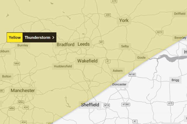

“Heavy showers will develop this evening, becoming more frequent and widespread overnight. These are likely to bring 15 to 20 mm in an hour in some areas with as much as 30 to 50 mm falling in a period of six hours in some places. These accumulations may lead to a few places seeing some flooding. Alongside the rain, some showers are likely to be thundery, bringing the additional hazards of lightning and hail. The showers will ease from the northwest Thursday morning.”
Met Office Yorkshire and Humber weather forecast
Wednesday day (19 August)
Mostly cloudy with scattered showers moving through from the northwest. Showers likely to turn heavy at times with a risk of hail and thunder, though turning drier and brighter later in the afternoon. Light westerly winds freshening in showers. Maximum temperature 20 °C.
Wednesday night (19 August)
A dry start to the evening but showers move into the north of the region, bringing heavy downpours and thunder at times. These moves southwards during the early hours. Minimum temperature 11 °C.
Thursday (20 August)
Heavy and thundery showers continue to move southwards across the region through the morning. Turning drier and brighter into the afternoon. Slightly fresher than Wednesday. Maximum temperature 18 °C.
Outlook for Friday (21 August) to Sunday (23 August)
Temperatures staying below average into the weekend. Isolated showers continuing but becoming more settled again by Sunday with sunny spells throughout.