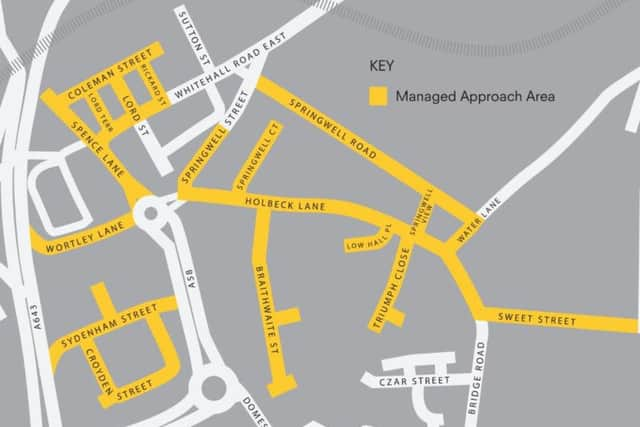
This map shows the exact streets and boundaries of Leeds 'legal red light zone'


Dubbed a 'legal red light zone', it is an area where sex workers can ply for trade without fear of arrest within agreed hours.

The Yorkshire Evening Post requested a copy of the map in December 2018 in a press breifing where they gave a rare update on the scheme.
Advertisement
Hide AdAdvertisement
Hide AdIt is only after the YEP submitted an FOI request that the map has been shared more widely.
Leeds City Council said: "The Managed Approach has never been promoted or advertised as an example of best practice, nor is it a ‘legal red light zone’ as is frequently reported."This map is distributed by the Safer Leeds partnership to define the Managed Approach area for the reference of those impacted by the scheme. This includes local residents, community groups and businesses. It is also designed to clearly set out the rules and operational boundaries of the area for street based sex workers and those who may be purchasers of sex."Its purpose is clear and we do not want it to be mis-used so that more people who may be purchasers are attracted to the area. One of our key aims is to reduce the prevalence of street sex work and we work hard with partners to support women in exiting this."This map is intended to help inform tackling a specific issue with street based sex work that has been occurring for many years in this particular area. Therefore it has never been advertised more widely than to appropriate stakeholders."
The YEP also requested information on the consultation conducted by the council prior to the release of the map.
The council said: "Consultation was undertaken with local residents, businesses and sex workers in relation to the publication of this map."Consultation was led by partners of Safer Leeds and other stakeholders."A local community group took responsibility for seeking the views of residents and consultation with businesses was undertaken by the neighbourhood policing team. Two third sector organisations who provide support services to the women who work in the area sought the view of sex workers."All of this feedback was provided verbally to Safer Leeds and therefore we do not have copies of consultation documents or reports summarising the responses received. However, the verbal feedback received from each partner and stakeholder advised us that an overwhelming majority of those consulted thought that the map should be made public."