Leeds battered by high winds & torrential rain as Storm Doris hits
This article contains affiliate links. We may earn a small commission on items purchased through this article, but that does not affect our editorial judgement.


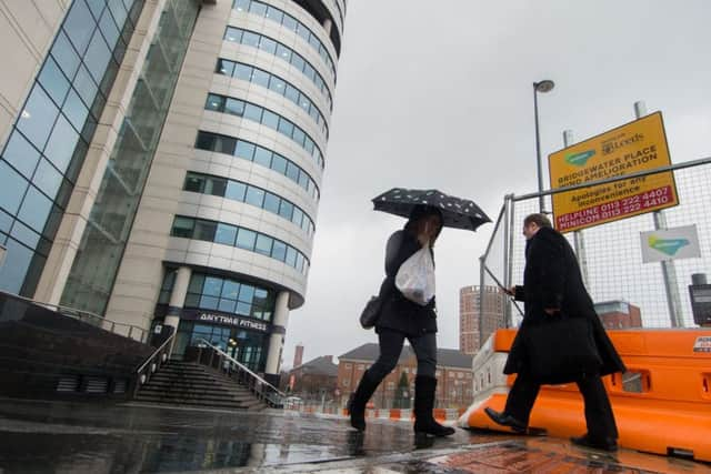
Due to high winds, roads around Bridgewater Place in the city centre closed from 1pm. Diversions are likely to stay in place until 5pm but will be monitored.
Severe weather warnings have been put in place for much of the country, with the North and Midlands urged to “be prepared” for winds of up to 80mph.
Advertisement
Hide AdAdvertisement
Hide Ad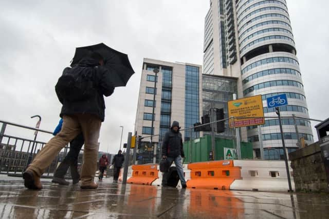
High winds and rain have already battered parts of Ireland and Wales this morning with the Met Office now predicting that the storm is getting bigger with every mile it moves across the country. Almost the whole of England and Wales are now expected to be affected in some way.
The Highways Agency has warned motorists to take extra caution today and released a list of roads where they believe Storm Doris could cause problems. (See list below)
Advertisement
Hide AdAdvertisement
Hide Ad“We have got a fairly active area of low pressure coming in from the Atlantic,” said Met Office forecaster Emma Sharples. “It is strengthening as it moves eastwards to the UK.”
The Met Office’s amber weather warning alerts people that “whilst the strongest winds look to be only short-lived, damage to structures, interruptions to power supplies and widespread disruption to travel networks are likely, with a danger of injury from flying debris”.
A weather warning for snow is also in place for Scotland, which could see treacherous blizzard-like conditions.
Storm Doris is expected to move on quickly, with the worst of the weather gone by Thursday evening. The Environment Agency warned there was a risk of localised flooding from Doris.
Advertisement
Hide AdAdvertisement
Hide AdA spokesman said: “Rain on saturated ground on Saturday could also lead to flooding in some areas.
“Environment Agency teams are out on the ground clearing screens and will issue flood warnings and alerts where necessary.”
The agency said it was training new staff on how to deploy temporary flood barriers, but there were no plans to use them this week. While further Atlantic gusts will bring more rain and wind through the weekend and into next week, they are not expected to reach the heights of Doris.
Storms with the potential to cause substantial impact are named by the Met Office and Met Eireann, moving through the alphabet.
Advertisement
Hide AdAdvertisement
Hide AdThe first was named Abigail in November 2015, after members of the public suggested monikers for the “name our storms” project.
Forecasters are now in their second run through the alphabet. After Doris, Britons can expect to hear of Ewan, Fleur and Gabriel.
Storm Doris’s appearance contrasts with Monday’s temperatures, where visitors to Kew Gardens, west London, enjoyed the warmest day of the winter so far, at 18.3C (64.9F). Parts of London and the south of England had temperatures warmer than Ibiza, southern Spain and Menorca.
The Highways England sever weather alert is in place for the following roads in Yorkshire and the North East:
M1 J32 - M18 interchange
M1 J34 Tinsley Viaduct/Rotherham
M1 J39-J40 Crigglestone to Dewsbury
A628 Woodhead Pass
M62 J23-J25 Huddersfield to Brighouse
M62 J31-J32 Normanton to Pontefract
M62 J35a-J36 Rawcliffe Bridge, M18 interchange to J36 Goole
M62 J36-J37 River Ouse / Ouse Bridge
A1(M) J47-J49 Between A59 Knaresborough and A168 Dishforth
A1(M) J58-J65 Between A1 and Washington at J65
A66 Between M6 J40 - A1 (Scotch Corner)
A19 Hylton Bridge over River Wear
A19 Tees Viaduct
A19 Leven Viaduct
A69 Entire route Humber Bridge
Storm Doris bringing heavy rain and the risk of gales.
Today:
Advertisement
Hide AdAdvertisement
Hide AdHeavy and blustery rain at first. A drier interval, with lighter winds is then likely, although gales and some rain could persist in the south, leading to disruption. Further rain and brisk winds then spread south later, with showers following. Maximum Temperature 8 °C.
Tonight:
Brisk north to northwesterly winds will ease overnight with clear spells possible, but also isolated wintry showers. Feeling cold, with the risk of icy patches. Minimum Temperature 0 °C.
Friday:
A cold morning, with sunny spells and any wintry showers easing. However cloud will thicken from the west during the afternoon, with persistent rain moving into the Pennines by dusk. Maximum Temperature 7 °C.
Outlook for Saturday to Monday:
Cloudy, mild but windy Saturday, with further rain, heavy at times. Drier start Sunday, before further strong winds and rain gradually spread east. Colder Monday with sunny spells and showers.