Weather latest: Warm weather to continue, but will we see any more storms across Yorkshire?


Advertisement
Hide AdAdvertisement
Hide AdTemperatures soared to record levels on Tuesday, the hottest September day in more than 100 years.
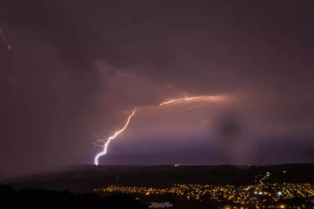
But the glorious sunshine gave way to downpours, thunder and lightning in many regions, causing chaos as roads were swallowed in deluges and trains, flights and football matches were disrupted.
Advertisement
Hide AdAdvertisement
Hide AdPublic Health England (PHE) said it was stepping up its heat warnings for people in the East Midlands and the East of England following high overnight temperatures and the continuing hotter weather.
The sunshine was postponed for many in Yorkshire as a large patch of mist and fog covered many parts for most of Wednesday morning. However, temperatures are expected to warm up once that has cleared, leading to renewed calls for people to respect the high temperatures.
PHE said the Met Office put the East Midland and East of England on Level 2 alert on Monday but on Wednesday that level had been increased to Level 3 and warned people should take action to reduce risks to their health from the heat.
The South East and London remain on Level 2 status, it said.
Advertisement
Hide AdAdvertisement
Hide AdDr Thomas Waite, of the Extreme Events team at PHE, said: “The hot weather is now here and likely to continue until Thursday, including overnight. It might be the end of the summer but those who are still at risk from the ill-effects of high temperatures are still at risk.
“That’s why it’s really important that we all think what we can do to make sure that older people, those with heart and lung conditions and those with very young children, don’t suffer from too much heat.”
Forecaster are expecting Wednesday to see fewer repeats of the spectacular storms which swept across parts of the country on Tuesday evening.
Readers of The Yorkshire Post sent in their own video clips of the storm as it made its way across the county on Tuesday evening. Some social media users even spotted a tornado-shaped cloud as Sheffield was battered by sheet rain, lightning strikes and hail stones.
Advertisement
Hide AdAdvertisement
Hide AdThe Met Office said Wednesday and Thursday would again be hot and sunny for most people.
Met Office spokesman Grahame Madge said temperatures would remain high on Wednesday and Thursday without quite reaching the record levels of Tuesday.
But Mr Madge said central London may still see thermometers getting close to the 30C (86F) mark.
He said: “It’s not necessarily the day-time highs that cause people problems, though. It’s the fact it’s been so hot day and night that is the issue here.”
Advertisement
Hide AdAdvertisement
Hide AdMr Madge said that slightly lower temperatures meant the thunderstorm risk was lower than on Tuesday.
But he said these storms were notoriously difficult to predict and, if they cropped up on Wednesday, Wales looked to be the most likely hot spot.
And he said the heatwave is likely to come to an end on Friday when a band of rain moves in from the Atlantic, bringing fresher weather and more seasonally normal temperatures for the weekend.
Yorkshire weather latest...
Today:
Another very warm and humid day with prolonged sunshine for most parts. Overnight, mist, fog and low cloud will clear many areas but may linger near the coast. Maximum Temperature 26 °C.
Tonight:
Advertisement
Hide AdAdvertisement
Hide AdA dry, warm night to come but the coastal fog will spread inland through the night becoming widespread by morning. Minimum Temperature 14 °C.
Thursday:
Extensive fog will be slow to clear through the morning although by afternoon some sunny spells are likely to develop, the best of these in the west. Remaining dry. Maximum Temperature 26 °C.
Outlook for Friday to Sunday:
Heavy showers at first Friday, clearing to sunny spells later. Breezy. Saturday mainly dry but bright, fresher start, some rain possible later. Sunday dry with sunny spells, rain by evening.
Read more...