80mph gusts forecast as Storm Doris heads for Leeds


Severe weather warnings have been put in place for much of the country, with the North and Midlands urged to “be prepared”.
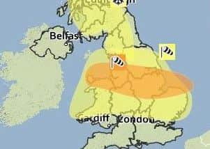
“Amber warnings” predict strong winds and heavy rain in Yorkshire, while winds as fast as 60mph are also expected to batter southern England.
Advertisement
Hide AdAdvertisement
Hide AdAcross Yorkshire, winds are expected to gust to 70 or 80mph for a short period.
Winds of up to 80mph are expected to plague northern Scotland on Wednesday before Doris arrives from the Atlantic on Thursday, the Met Office said.
Leeds Council is currently monitoring conditions at the nororious wind blackspot of Bridgewater Place.
High winds led to the cancellation of a London-bound flight from Leeds Bradford Airport this morning.
Advertisement
Hide AdAdvertisement
Hide AdPassengers due to fly on the 9.20am British Airways flight to London Heathrow were notified of the cancellation last night following the forecast of high winds for West Yorkshire area.
A Leeds Bradford Airport spokeswoman said: “All our operations teams are working hard to ensure everything is running as normally as possible and passengers are asked to contact their airline directly if they have any queries.”
Met Office forecaster, Emma Sharples, said: “We have got a fairly active area of low pressure coming in from the Atlantic. It is strengthening as it moves eastwards to the UK.”
The Met Office’s amber weather warning alerts people that “whilst the strongest winds look to be only short-lived, damage to structures, interruptions to power supplies and widespread disruption to travel networks are likely, with a danger of injury from flying debris”.
Advertisement
Hide AdAdvertisement
Hide AdA weather warning for snow is also in place for Scotland, which could see treacherous blizzard-like conditions.
Storm Doris is expected to move on quickly, with the worst of the weather gone by Thursday evening.
While further Atlantic gusts will bring more rain and wind through the weekend and into next week, they are not expected to reach the heights of Doris.
Storms with the potential to cause substantial impact are named by the Met Office and Met Eireann, moving through the alphabet.
Advertisement
Hide AdAdvertisement
Hide AdThe first was named Abigail in November 2015, after members of the public suggested monikers for the “name our storms” project.
Forecasters are now in their second run through the alphabet. After Doris, Britons can expect to hear of Ewan, Fleur and Gabriel.
Storm Doris’s appearance contrasts with Monday’s temperatures, where visitors to Kew Gardens, west London, enjoyed the warmest day of the winter so far, at 18.3C (64.9F).
Parts of London and the south of England had temperatures warmer than Ibiza, southern Spain and Menorca.